")
")
 |
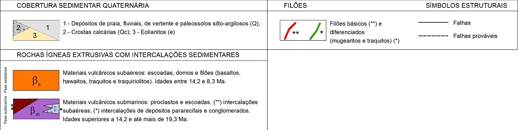
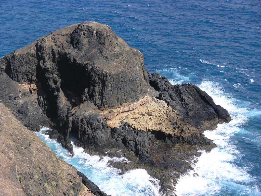
Geosite ID: PSt09 Name: Ilhéu de Cima - Cabeço das Laranjas Thematic category: Paleontology |
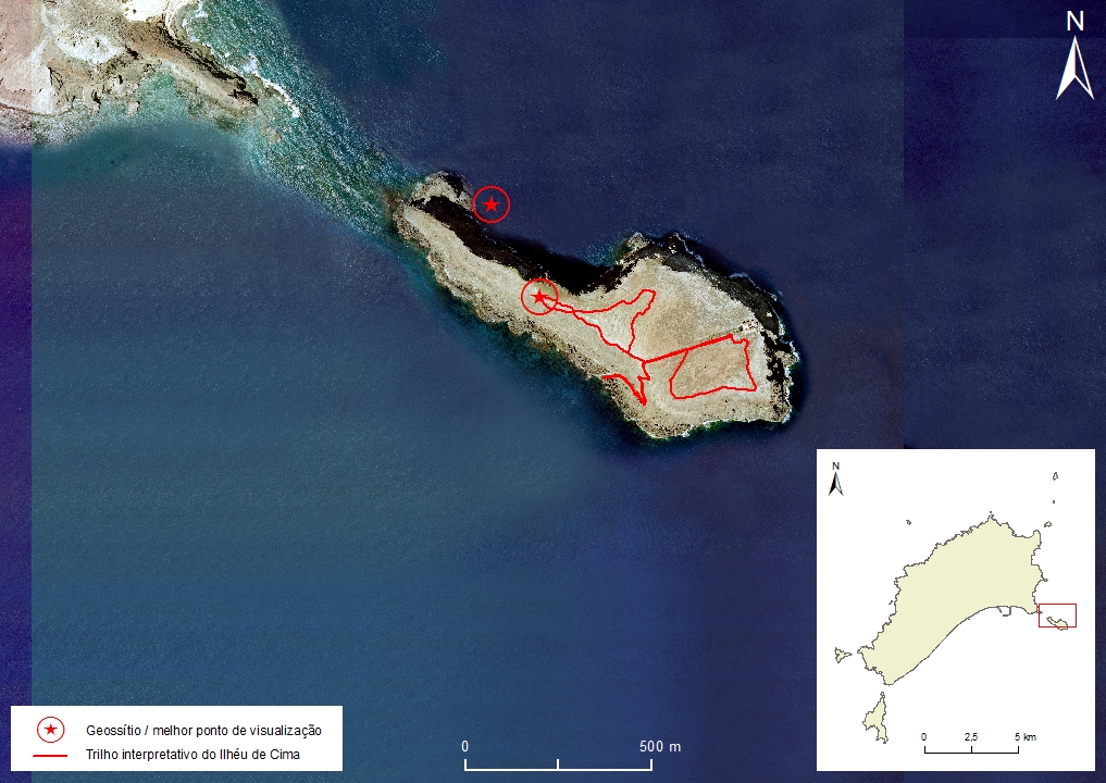 |
Municipality: Porto Santo Civil parish: Porto Santo Location area: 0.1-10 ha Coordinates(1): 33°03'19.53'' N 16°17'01.73'' W / 33°03'27.62'' N 16°17'10.40'' W Altitude: 81 m Accessibility: Easy Distance to nearest paved road: 2,1 nmi Conditions of observation: Good (1) Coordinates of the geosite and / or the best viewpoint |
Brief description
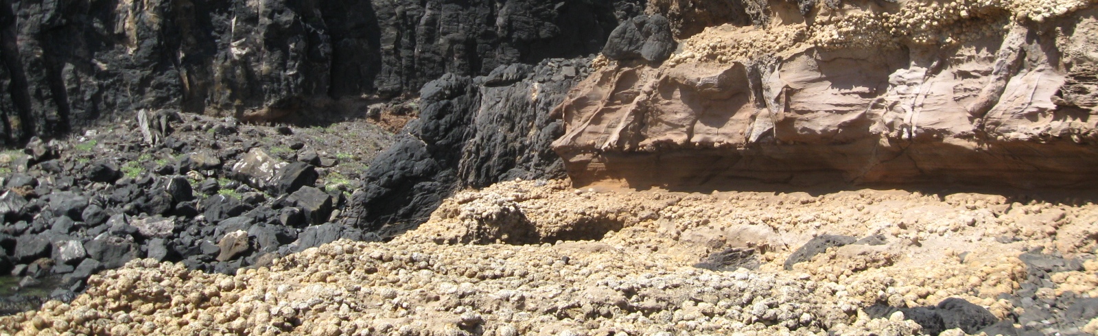
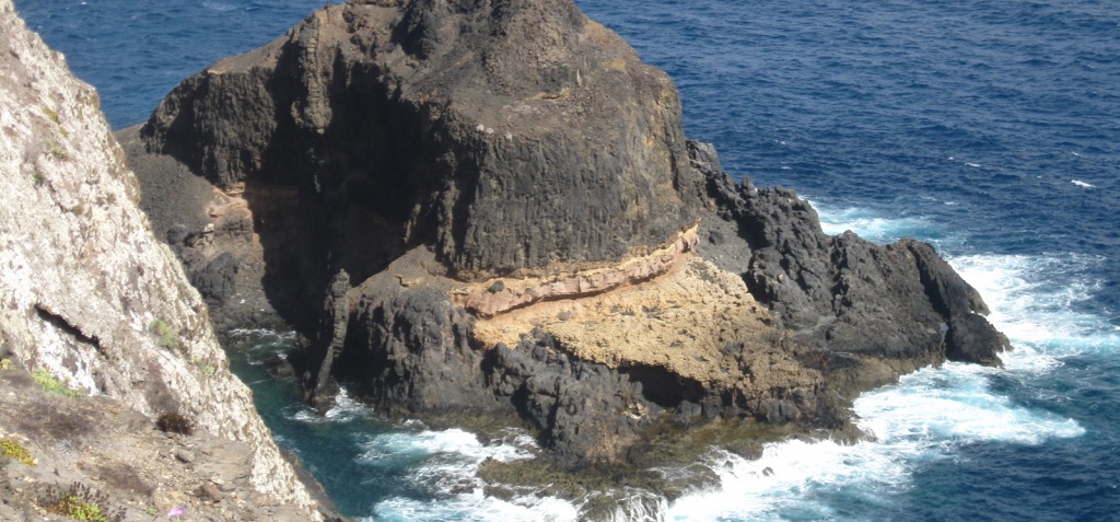
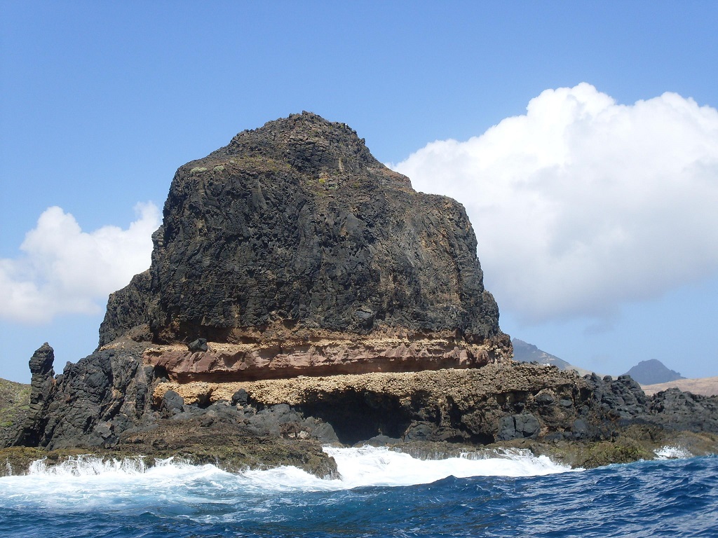
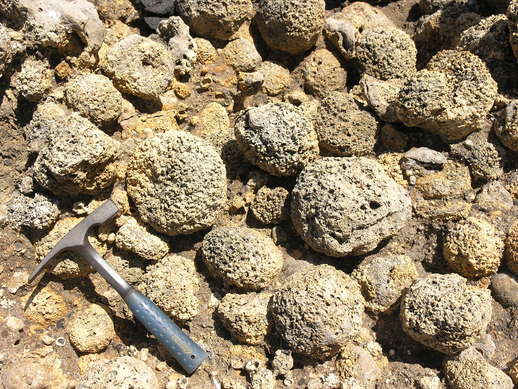
In the "Cabeço das Laranjas", in the NW tip of this islet, it is possible to observe a high concentration of fossilized rhodoliths, structures that were formed by calcareous algae of the red algae group, in the Miocene (15-14 My). These are contemporaneous to the pre-emergence phase of Porto Santo. These are found between two volcanic complexes, a basaltic submarine one, from between 18.8 and 13.5 My and another basaltic subaerial one, from between 14 and 10.2 My. This fact makes this outcrop a highly relevant site. The rhodoliths are locally known as "oranges" because of its resemblance to the fruit. Like the other islets, its individualization occurred after the last glaciation and the deposition of the aeolianitic formation during the Holocene.
Relevant notes
The visitation to the islanders requires prior authorization from the Institute of Forests and Nature Conservation (IFCN).
Visiting a site of geological interest is the sole responsibility of the user.
The user must take precautions when visiting the site, taking into account the conditions of the terrain, weather conditions and other hazards, so that they do not create situations that put themselves or others at risk.
The user must respect private property. Access to private areas requires prior authorization from the owners.
The user must respect natural heritage, keeping it intact. The impact of your actions should be minimal.
Protection status
Natura 2000 Network, Network of Marine Protected Areas of Porto Santo, Site of Community Importance PTPOR0001 - Ilhéus do Porto Santo, Scientific Heritage (geological) and Natural Areas of Interdiction, according to the Municipal Master Plan.
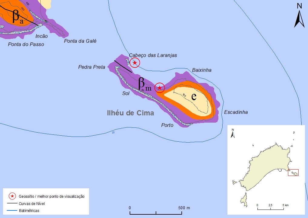
Simplified geological map of Porto Santo Island detail - PSt09
Bibliography
CACHÃO, M., RASSER, M., RODRIGUES, D., DA SILVA, C.M., 2000. Paleoenvironmental and Taphonomical Interpretation of Miocene Rhodoliths from Porto Santo (Madeira Archipelago, Portugal). Preliminary Data. I Congresso Ibérico de Paleontologia, Évora, Abstracts, pp. 42-43.
FERREIRA, M. R. (2014). Património Geológico da Ilha do Porto Santo e Ilhéus Adjacentes (Madeira): Inventariação, Avaliação e Valorização como Contributo para a Geoconservação. Dissertação de Mestrado em Vulcanologia e Riscos Geológicos. Departamento de Geociências da Universidade dos Açores.
JOHNSON, M. E., SILVA, C. M., SANTOS, A., BAARLI, B. , CACHÃO, M., MAYORAL, E., et al. (2011). Rhodolith transport and immobilization on a volcanically active rocky shore: Middle Miocene at Cabeço das Laranjas on Ilhéu de Cima (Madeira Archipelago, Portugal). Elsevier - Palaeogeography, Palaeoclimatology, Palaeoecology 300, 113-127.
RIBEIRO, M. L. Carta Geológica Simplificada das Ilhas da Madeira e do Porto Santo, na escala 1:80.000 in RIBEIRO, M. L. & RAMALHO, M. (2009). Uma visita geológica ao Arquipélago da Madeira, Principais locais Geo-turísticos. Edição da Direção Regional do Comércio, Indústria e Energia e do Laboratório Nacional de Energia e Geologia, I. P, pp. 55, 82. ISBN: 978-989-96202-0-9.
SANTOS, A., MAYORAL, E., DA SILVA, C. M., CACHÃO, M., JOHNSON, M. E., BAARLI, B.G. (2011). Miocene intertidal zonation on a volcanically active shoreline: Porto Santo in the Madeira Archipelago, Portugal. Lethaia 44, pp. 26-32.
SANTOS, A., MAYORAL, E., BAARLI, B. G., DA SILVA, C. M., CACHÃO, M., JOHNSON, M. E. (2012a). Symbiotic association of a pyrgomatid barnacle with a coral from a volcanic middle Miocene shoreline (Porto Santo, Madeira Archipelago, Portugal). Palaeontology Vol. 55, Part 1, pp. 173-182.
SANTOS, A., MAYORAL, E., JOHNSON, M. E., BAARLI, B. G., CACHÃO, M., DA SILVA, C. M., LEDESMA-VÁSQUEZ, J. (2012b). Extreme habitat adaptation by boring bivalves on volcanically active paleoshores from North Atlantic Macaronesia. Facies 58, pp. 325-338.
SANTOS, A., MAYORAL, E., JOHNSON, M. E., BAARLI, B. G., DA SILVA, C. M., CACHÃO, M, LEDESMA-VÁZQUEZ, J. (2012). Basalt mounds and adjacent depressions attract contrasting biofacies on a volcanically active Middle Miocene coastline (Porto Santo, Madeira Archipelago, Portugal). Facies 58, pp. 573-585.
Photo gallery
How to Cite
FERREIRA, M. R. (2014). Património Geológico da Ilha do Porto Santo e Ilhéus Adjacentes (Madeira): Inventariação, Avaliação e Valorização como Contributo para a Geoconservação. Dissertação de Mestrado em Vulcanologia e Riscos Geológicos. Departamento de Geociências da Universidade dos Açores. In: https://geodiversidade.