")
")
 |
Geosite ID: SV03 Name: Lameiros Thematic category: Stratigraphy, Paleontology, Sedimentology and Lithology |
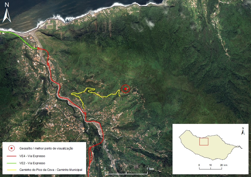 |
Municipality: São Vicente Civil parish: São Vicente Location area: 0,1 - 10 ha Coordinates(1):32°47'51.7'' N 17°01'20.4'' W Altitude: 455 m Accessibility: Easy Distance to nearest paved road: 100 m Conditions of observation: Good (1) Coordinates of the geosite and / or the best viewpoint |
Brief description
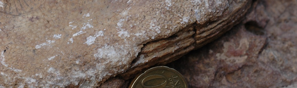
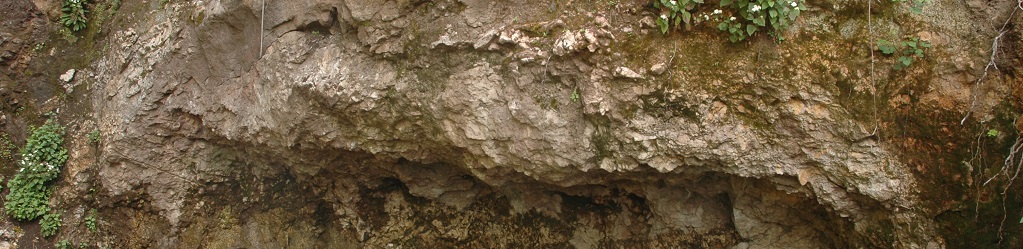
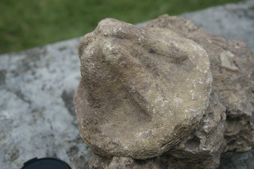
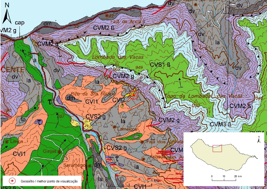
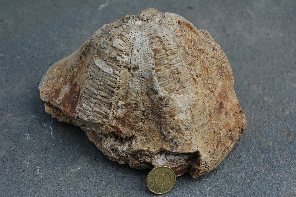
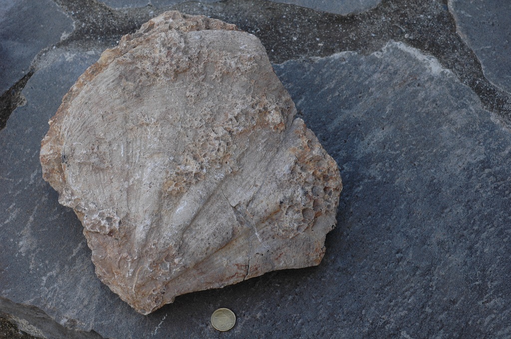
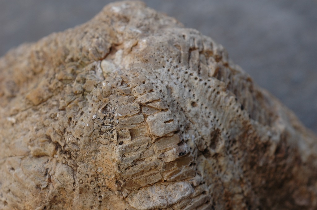
The Lameiros (Corgo do Barrinho) site is the only place on all of Madeira Island where fossiliferous marine sediments occur, at an altitude between 320 m and 475 m. These carbonated sediments from the Miocene (6-7 Ma) are correlated with a marine neritic and reef environment and were formed at shallows depth. This set of outcrops, due to its integrity and representativeness, should be used as a reference when characterising the Lameiros Formation that belongs to the Lower Volcanic Complex (CVI), defining its simple stratigraphy. The sedimentary deposits are crucial for the understanding of the initial stages of the development of the Madeiran island edifice.
Relevant notes
Visiting a site of geological interest is the sole responsibility of the user.
The user must take precautions when visiting the site, taking into account the conditions of the terrain, weather conditions and other hazards, so that they do not create situations that put themselves or others at risk.
The user must respect private property. Access to private areas requires prior authorization from the owners.
The user must respect natural heritage, keeping it intact. The impact of your actions should be minimal.
Protection status
Classified as a Public Interest Group by the Regional Secretariat for Tourism and Culture in 2005 (IP JO 1.ª série, nº 124 Port. 115/05 03/10/05).
Agroforestry spaces - Forest spaces - natural forest (Article 43), according to Municipal Master Plan.
ZPE of the Laurissilva of Madeira, which coincides with the limits of the ZEC of the Laurissilva of Madeira, and Natural Park of Madeira (Decreto Regulamentar Regional n.º 3/2014/M, artigo 2.º, alínea a).
Geological map of Madeira Island detail, Sheet a - SV03

Bibliography
BRUM DA SILVEIRA, A.; MADEIRA, J.; RAMALHO, R.; FONSECA, P., PRADA, S. (2010) - Notícia Explicativa da Carta Geológica da ilha da Madeira, na escala 1:50.000, folhas A e B. Edição da Secretaria Regional do Ambiente e Recursos Naturais, Região Autónoma da Madeira e Universidade da Madeira: 47 p. ISBN: 978-972-98405-2-4. (Editado em 2011).
BRUM DA SILVEIRA, A.; MADEIRA, J.; RAMALHO, R.; FONSECA, P.; RODRIGUES, C., PRADA, S. (2010) Carta Geológica da ilha da Madeira na escala 1:50.000 - Folha A e B. Edição da Região Autónoma da Madeira, Secretaria Regional do Ambiente e Recursos Naturais; ISBN: 978-972-98405-1-7 (Editado em 2011).
BRUM DA SILVEIRA, A.; PRADA, S.; RAMALHO, R.; MADEIRA, J.; FONSECA, P.; CANHA, E.; BRILHA, J. (2012). Inventariação do Património Geológico da ilha da Madeira. Secretaria Regional do Ambiente - Relatório Final, 414 p.
ROMARIZ, C. (1971A) Notas petrográficas sobre rochas sedimentares portuguesas. XI - Os biocalcaritos neríticos de S. Vicente (ilha da Madeira). Boletim do Museu e Laboratório Mineralógico e Geológico da Faculdade de Ciências de Lisboa 12 (1): 27-35.
ROMARIZ, C. (1971B) Notas petrográficas sobre rochas sedimentares portuguesas. XII- Calcaritos afânicos da ilha da Madeira. Boletim do Museu e Laboratório Mineralógico e Geológico da Faculdade de Ciências de Lisboa 12(1): 55-65.
ZBYSZEWSKI, G.; VEIGA FERREIRA, O.; CÂNDIDO DE MEDEIROS, A.; AIRES-BARROS, L.; CELESTI- NO SILVA, L.; MUNHÁ, J.M. & BARRIGA, F. (1975) Carta Geológica de Portugal na escala 1:50.000. Notícia Explicativa das Folha A e B da ilha da Madeira. Serviços Geológicos de Portugal: 53 p.
Photo gallery
How to Cite
BRUM DA SILVEIRA, A.; PRADA, S.; RAMALHO, R.; MADEIRA, J.; FONSECA, P.; CANHA, E.; BRILHA, J. (2012). Inventariação do Património Geológico da Ilha da Madeira. Secretaria Regional do Ambiente e Recursos Naturais - Relatório Final, 414 p. In: https://geodiversidade.