")
")
 |
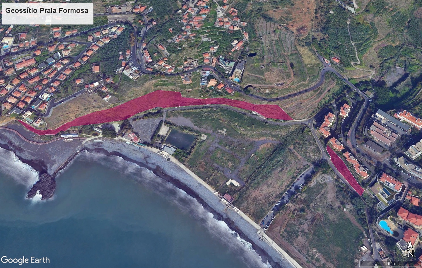
Geosite ID: F02 Name: Praia Formosa |
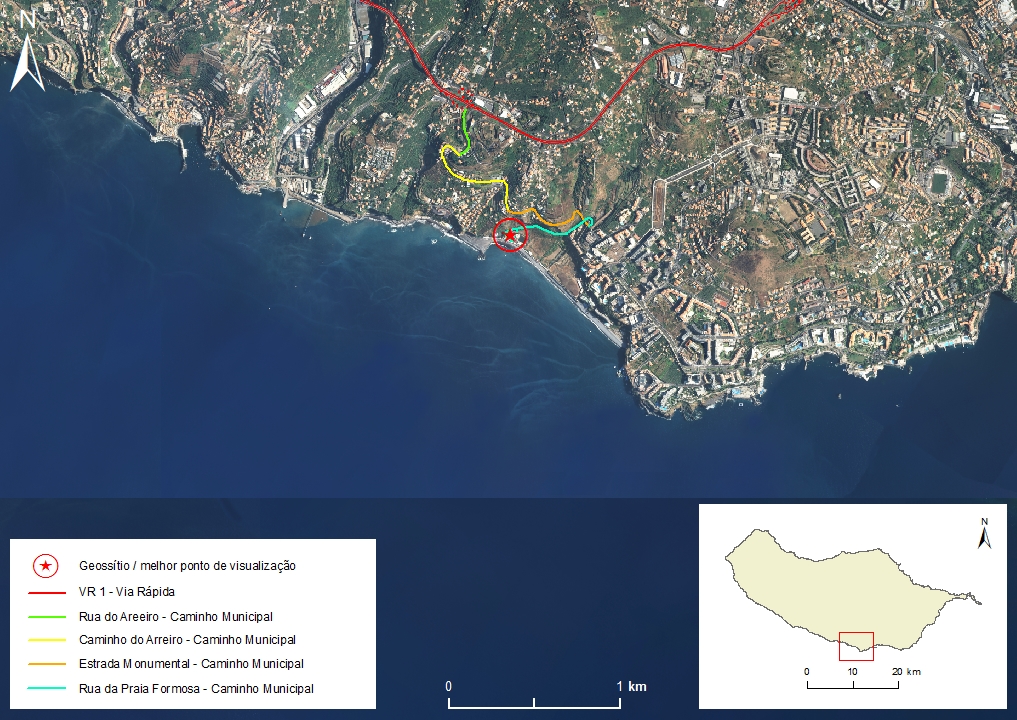 |
Municipality: Funchal Civil parish: São Martinho Location area: 0,1 -10 ha Coordinates(1) Altitude: 10 m Accessibility: Easy Distance to nearest paved road:0 m Conditions of observation: good (1) Coordinates of the geosite and / or the best viewpoint |
Brief description
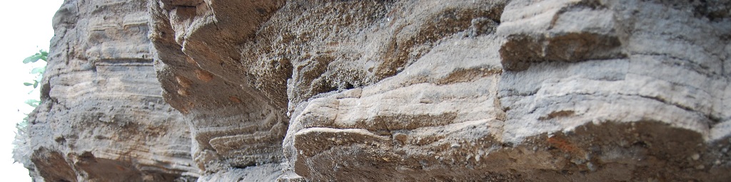
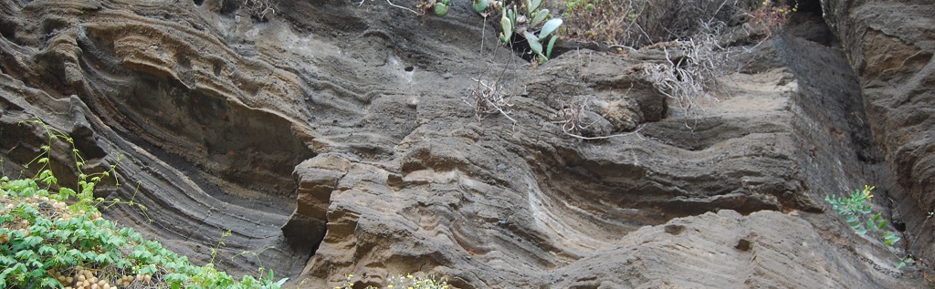
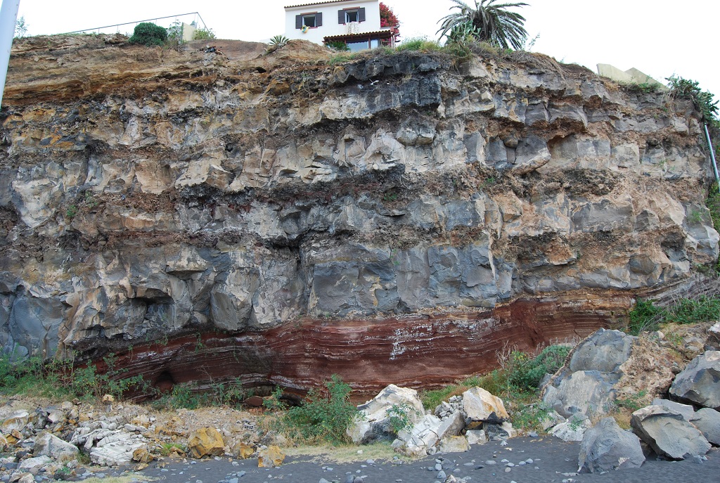
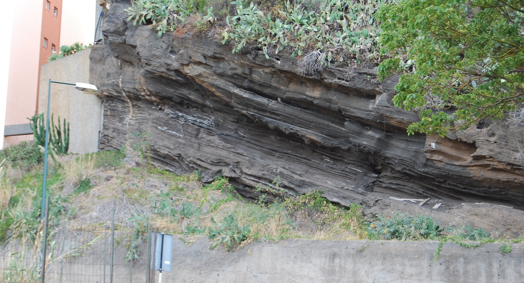
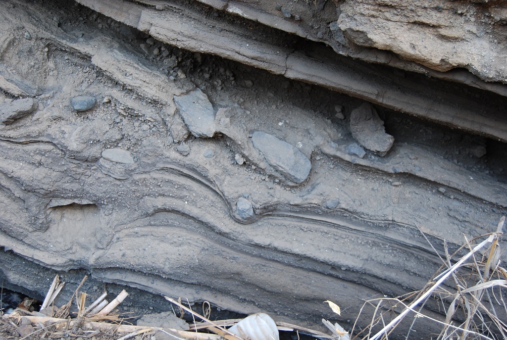
On the Praia Formosa geosite there are several volcanic sequences that make up the Funchal Formation (Upper Volcanic Complex). In general, the following sucession is observed (from bottom to top): 1- basaltic pyroclastic deposits, with bombs and red lapilli layers, from a monogenetic subaerial cone formed by strombolian-type eruptive activity; 2- Black pyroclastic deposits of basaltic lapilli from nearby subaerial cones (eg Pico da Cruz and Pico do Funcho); 3- grey basaltic pyroclastic deposits from a surtseyan-type hydrovolcanic cone with multiple impact structures produced by lithic blocks and fragments that were projected with a ballistic trajectory, accretionary lapilli layers and well stratified ash layers associated with basal pyroclastic flows; 4- pyroclastic deposits of hydrovolcanic origin, composed of yellow tuff, (and tuffite) with layers of weathered trachytic pumice, related to hydroplinian-type distal eruptions; 5- Subaerial ’a’a-type basaltic flows sequences, sometimes interspersed with lapilli deposits; 6- tuff of hydrovolcanic origin, yellow in colour with weathered trachytic pumice layers related to hydroplinian-type distal eruptions. For its integrity and representativeness, this site should be used as a reference in defining the simple stratotype of the Funchal Formation.
Relevant notes
Visiting a site of geological interest is the sole responsibility of the user.
The user must take precautions when visiting the site, taking into account the conditions of the terrain, weather conditions and other hazards, so that they do not create situations that put themselves or others at risk.
The user must respect private property. Access to private areas requires prior authorization from the owners.
The user must respect natural heritage, keeping it intact. The impact of your actions should be minimal.
Protection status
Location
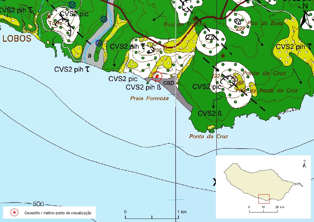
Geological map of Madeira Island detail, Sheet a and b - F02

Bibliography
BRUM DA SILVEIRA, A.; MADEIRA, J.; RAMALHO, R.; FONSECA, P., PRADA, S. (2010) - Notícia Explicativa da Carta Geológica da ilha da Madeira, na escala 1:50.000, folhas A e B. Edição da Secretaria Regional do Ambiente e Recursos Naturais, Região Autónoma da Madeira e Universidade da Madeira: 47 p. ISBN: 978-972-98405-2-4. (Editado em 2011).
BRUM DA SILVEIRA, A.; MADEIRA, J.; RAMALHO, R.; FONSECA, P.; RODRIGUES, C., PRADA, S. (2010) Carta Geológica da ilha da Madeira na escala 1:50.000 - Folha A e B. Edição da Região Autónoma da Madeira, Secretaria Regional do Ambiente e Recursos Naturais; ISBN: 978-972-98405-1-7 (Editado em 2011).
BRUM DA SILVEIRA, A.; MADEIRA, J.; RAMALHO, R. (2014). Geology of Madeira Island - Field Trip Guide. 1.st International Workshop on Volcano Geology (Madeira, Portugal).
Photo gallery
How to Cite
BRUM DA SILVEIRA, A.; PRADA, S.; RAMALHO, R.; MADEIRA, J.; FONSECA, P.; CANHA, E.; BRILHA, J. (2012). Inventariação do Património Geológico da Ilha da Madeira. Secretaria Regional do Ambiente e Recursos Naturais - Relatório Final, 414 p. In: https://geodiversidade.