")
")
 |
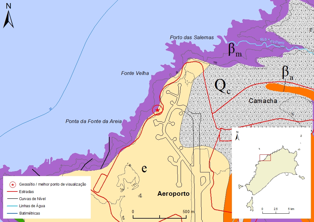
Geosite ID: PSt07 Name: Fonte da Areia Thematic category: Geomorfology, sedimentology and paleontology |
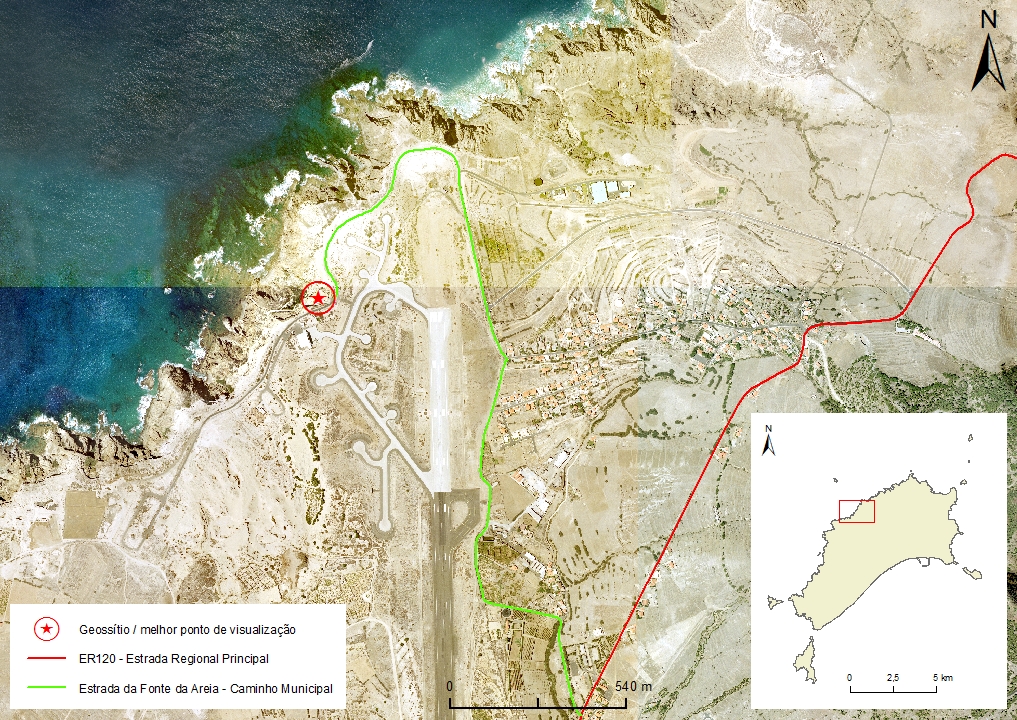 |
Municipality: Porto Santo Civil parish: Porto Santo Location area: 0.1-10 ha Coordinates(1):33°05'13.30'' N 16°21'16.60'' W Altitude: 100 m Accessibility: Easy Distance to nearest paved road: 25 m Conditions of observation: Good (1) Coordinates of the geosite and / or the best viewpoint |
Brief description
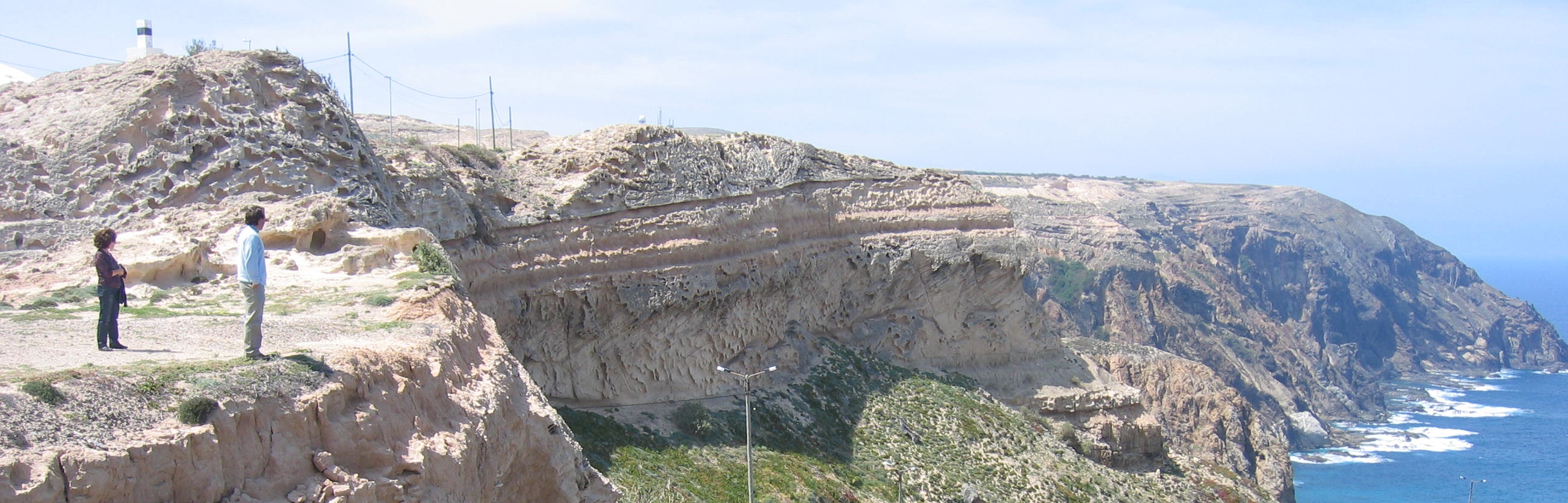
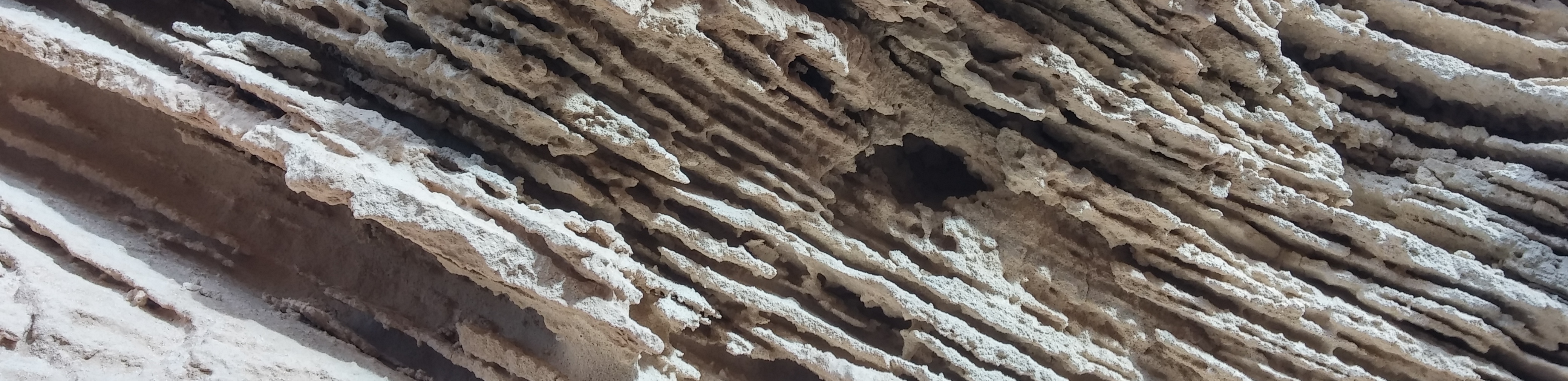
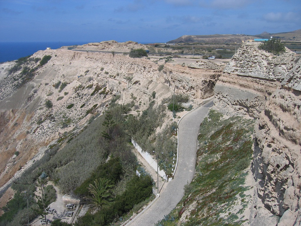
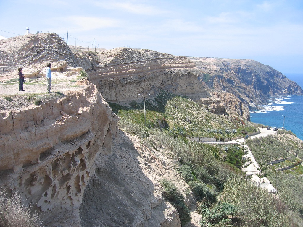
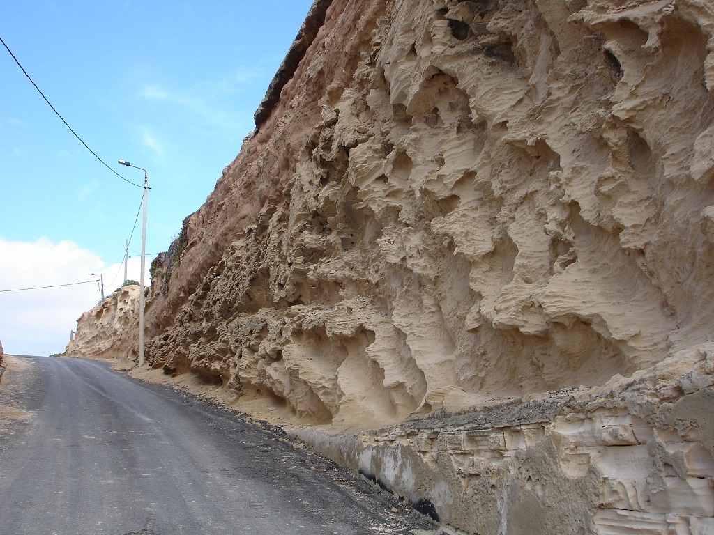
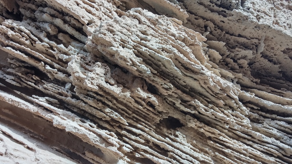
In here, it is possible to find the large aeolianitic calcarenites accumulations from the Quaternary that, as in "Morenos" and "Serra de Fora", belong to the Aeolianitic Formation. These former marine sands were remobilized from the insular platform that was exposed during glacial periods, when the sea level was lower than today, and experienced wind transport to depositional locations. The availability of sand seems to have been greater in the north, where the older accumulations appear, with around 31 thousand years. Four distinct units are known, intercalated with layers of paleosols, which correspond to interludes in the transport and accumulation of these sands. The stratification type suggests that the wind dominance was from the northern quadrant. It is also possible to observe old calcareous crusts, locally referred as "laginhas de cal". The presence of fossils of land pulmonated gastropods and root casts is a testimony of biological occupation this coastal habitat.
Relevant notes
Visiting a site of geological interest is the sole responsibility of the user.
The user must take precautions when visiting the site, taking into account the conditions of the terrain, weather conditions and other hazards, so that they do not create situations that put themselves or others at risk.
The user must respect private property. Access to private areas requires prior authorization from the owners.
The user must respect natural heritage, keeping it intact. The impact of your actions should be minimal.
Protection status
Scientific (geological) Heritage and Natural Areas of Strongly Conditioned Use, according to the Municipal Master Plan.
Simplified geological map of Porto Santo Island detail - PSt07
Bibliography
DE CARVALHO, A. G. & BRANDÃO, J. (1991). A Geologia do Arquipélago da Madeira. Museu Nacional de História Natural, pp.170.
FERREIRA, M. R. (2014). Património Geológico da Ilha do Porto Santo e Ilhéus Adjacentes (Madeira): Inventariação, Avaliação e Valorização como Contributo para a Geoconservação. Dissertação de Mestrado em Vulcanologia e Riscos Geológicos. Departamento de Geociências da Universidade dos Açores.
MOURA, A. R. (1961). Foraminíferos das areias de praia e dos calcoarenitos da ilha de Porto Santo. Memórias e Notícias, Publ. Museu Lab. Mineral. Geol. Universidade Coimbra, n.º 51, pp. 63-82.
RIBEIRO, M. L. Carta Geológica Simplificada das Ilhas da Madeira e do Porto Santo, na escala 1:80.000 in RIBEIRO, M. L. & RAMALHO, M. (2009). Uma visita geológica ao Arquipélago da Madeira, Principais locais Geo-turísticos. Edição da Direção Regional do Comércio, Indústria e Energia e do Laboratório Nacional de Energia e Geologia, I. P, pp. 55, 82. ISBN: 978-989-96202-0-9.
RIBEIRO, M. L. & RAMALHO, M. (2009). Uma Visita Geológica ao Arquipélago da Madeira: Principais Locais Geo-turísticos. Direção Regional do Comércio, Indústria e Energia da RAM e Laboratório Nacional de Energia e Geologia, I. P., Lisboa.
SILVA, J. (2003). Areia de Praia da Ilha do Porto Santo: geologia, génese, dinâmica e propriedades justificativas do seu interesse medicinal. Madeira Rochas – Divulgações Científicas e Culturais, 344 pp.
SOARES, A., CALLAPEZ, P. & MARQUES, J. (2006). Aprender em Viagem – Geologia de Porto Santo (notas para uma viagem de estudo). Revista da Associação Portuguesa de Professores de Biologia e Geologia, n.º 27, pp. 7-45.
Photo gallery
How to Cite
FERREIRA, M. R. (2014). Património Geológico da Ilha do Porto Santo e Ilhéus Adjacentes (Madeira): Inventariação, Avaliação e Valorização como Contributo para a Geoconservação. Dissertação de Mestrado em Vulcanologia e Riscos Geológicos. Departamento de Geociências da Universidade dos Açores. In: https://geodiversidade.