")
")
Madeira archipelago is formed by the islands of Madeira, Porto Santo, Desertas (Deserta Grande, Ilhéu Chão and Bugio) and Selvagens (Selvagem Grande and Selvagem Pequena). Of these, only Madeira and Porto Santo are inhabited, whereas Selvagem Grande and Deserta Grande, both part of natural reserves, are inhabited by a permanent contingent of Nature Wardens.
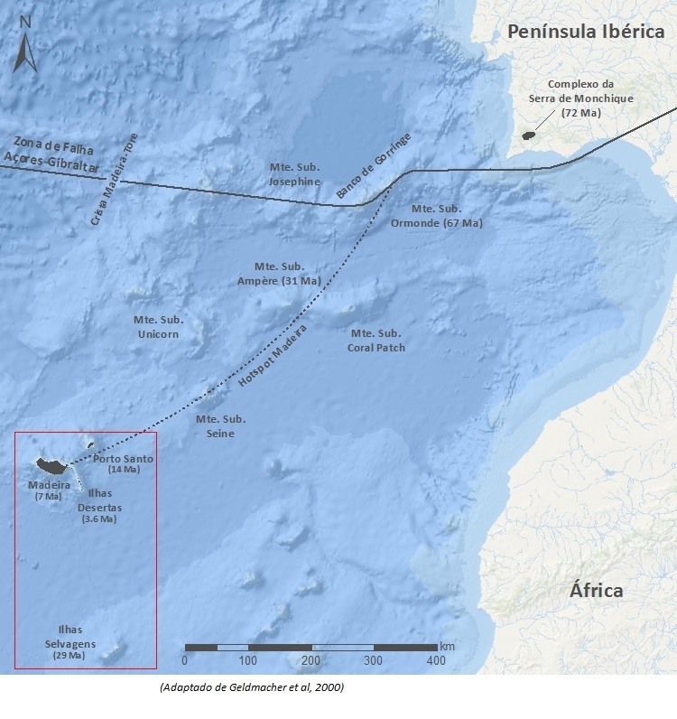
From a geodynamic point of view, the archipelago is located in the northwest sector of the African plate (Nubian plate), about 500 km south from the Azores-Gibraltar fault zone, 1600 km east from the Mid-Atlantic Ridge and 640 km to the west from the African continental margin.
Madeira Island represents the emerged part of a huge volcanic shield, of Miocenic to Holocenic age (7 Ma), built over a Cretaceous oceanic crust. Its building is the result of submarine volcanic activity, and, later, by the stacking of subaerial eruptions generated mostly by fissural activity along a principal axis of approximate direction E-W.
Its lavas are alkaline, and the less differentiated lithotypes such as basanites and alkaline basalts, predominate. Intermediate rocks, such as mugearites and trachytes, are represented in rare outcrops.
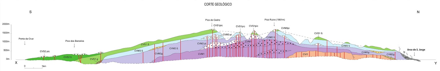
Three main volcanic complexes are identified in Madeira. These are formed by seven volcano-stratigraphic units or formations, separated by unconformity surfaces, expressed at a regional level.
The Lower Volcanic Complex (CVI) - (Miocene > 7 Ma) represents the ending of the submarine stage of the volcano and is subdivided into:
• Porto da Cruz Formation (CVI1) – consisting of very weathered rocks, from hydromagmatic origin (hyaloclastite, hyaloclastite breccia and submarine lava flows), cut by a dense network of dykes;
• Lameiros Formation (CVI2) – formed by a fossiliferous sequence of carbonated shallow marine sediments. It is exposed at an altitude of 400 m, above sea level, in Lameiros region, which suggests an important island uplift.
The Intermediate Volcanic Complex (CVM) (Plio-Pleistocene ~5,57-1,8Ma) corresponds to the main subaerial building phase of the shield volcano, and is subdivided into:
• Encumeada Formation (CVM1) – characterized by strombolian and volcanian eruptions in cones or fissural systems along an E-W rift zone, and covers the current central and oriental sectors of the island;
• Penha de Águia Formation (CVM2) – characterized by numerous eruptions (strombolian and hawaiian types) that poured a great volume of lava from eruptive centers located mainly in the Central Mountain Massif, that significantly increased the emerged volume of the island;
- Curral das Freiras Formation (CVM3) – characterized essentially by hawaiian type volcanism (or strombolian type) in fissural centers probably located in the Paul da Serra region. It corresponded to the western sector growth phase of the island.
The Upper Volcanic Complex (CVS) – (Pleisto-Holocene ~1,8-0,007 Ma) corresponds to the volcanic capping phase and post-erosional volcanism, in eruptive centers or fissural systems along NW-SE to WNW-ESE volcanic rift zones, subdivided by:
- Lombos Formation (CVS1) – capping stage of the island in a top position and, in some cases, filling valleys related to the current morphology;
- Funchal Formation (CVS2) – post-erosional volcanism, namely, contemporary to the actual morphology.
Breccia and conglomerate epiclastic sedimentary deposits are present in the various stratigraphic units and show, among others, important mass movements (lahars, landslides, etc.) related to the rugged relief of the island.
In addition to the aforementioned formations the following stands out: granular rocks occuring in the Lower Volcanic Complex - Porto da Cruz Formation (CVI1); dykes and dyke masses in the Central Mountain Massif and Ponta de São Lourenço; beach sands; aeolian deposits; glacial and periglacial deposits.
The last eruption dates back about 6850 years ago and, currently, secondary volcanism manifestations still occur, such as the release of gas (CO2) and hot springs.
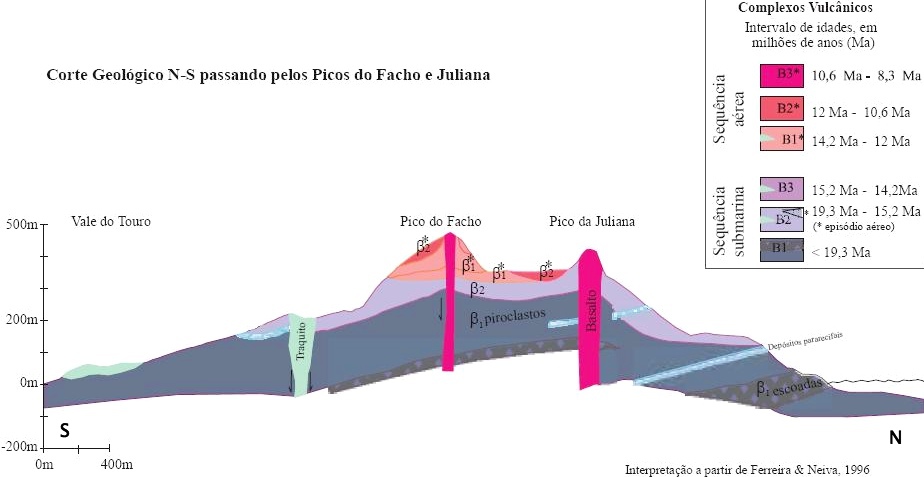
Porto Santo Island, is characterized by a complex structure that results from its submarine, transitional and subaerial building phases. It has developed as a submarine shield volcano during the Lower Miocene, about 18 million years ago.
From 14.5 Ma, the island emerged through both submarine and subaerial volcanic events, prevailing the latter at around 13.5 Ma. The latest eruptions from this phase occurred 10.2 million years ago, with the formation of the Pico de Juliana chimney. The eruptive activity continued with dyke intrusions, and shall have been extinguished about 8 million years ago.
The magmatic rocks are moderately alkaline, and magmatic differentiation processes have generated oversaturated lithotypes such as trachytes and rhyolites.
Sedimentary rocks outcrops are also present, and form two major units. The first, from the Middle Miocene, is contemporary to the volcanic activity that occurred during the transition phase, between the submarine and subaerial volcanism and is depicted by calcarenites or biocalcarenites, such as the Ilhéu da Cal reef structures.
The other sedimentary outcrop, formed in a subaerial environment during the Pleistocene, is formed by biogenic carbonated sandstone, that were accumulated and consolidated into aeolian calcarenites. Examples are the Calhau da Serra de Fora and the Fonte da Areia deposits.
Bibliography
BRUM DA SILVEIRA, A.; MADEIRA, J.; RAMALHO, R.; FONSECA, P., PRADA, S. (2010) - Notícia Explicativa da Carta Geológica da ilha da Madeira, na escala 1:50.000, folhas A e B. Edição da Secretaria Regional do Ambiente e Recursos Naturais, Região Autónoma da Madeira e Universidade da Madeira: 47 p. ISBN: 978-972-98405-2-4. (Editado em 2011).
BRUM DA SILVEIRA, A.; MADEIRA, J.; RAMALHO, R.; FONSECA, P.; RODRIGUES, C., PRADA, S. (2010) Carta Geológica da ilha da Madeira na escala 1:50.000 - Folha A e B. Edição da Região Autónoma da Madeira, Secretaria Regional do Ambiente e Recursos Naturais; ISBN: 978-972-98405-1-7 (Editado em 2011).
BRUM DA SILVEIRA, A.; MADEIRA, J.; RAMALHO, R.; FONSECA, P.; PRADA, S. (2012). Vulcano-estratigrafia da ilha da Madeira, 46º Congresso Brasileiro de Geologia e 1º Congresso de Geologia dos Países de Língua Portuguesa, Santos, Brasil, setembro de 2012.
GELDMACHER, J.; BOGAARD, P.; HOERNLE, K. & SCHMINCKE, H.-U. (2000). The 40Ar/39Ar age dating of the Madeira Archipelago and hotspot track (eastern North Atlantic). Geochemistry Geophysics Geosystems 1, n.º 1.
GELDMACHER, J.; HOERNLE, K.; BOGAARD, P.; DUGGEN, S. & WERNER, R. (2005). New 40Ar/39Ar age and geochemical data from seamounts in the Canary and Madeira volcanic provinces: Support for the mantle plume hypothesis. Earth Planetary Science Letters 237, pp 85-101.
GELDMACHER, J., HOERNLE, K., BOGAARD, P., ZANKI, G. & GARBE-SCHÖNBERG, D. (2001). Earlier history of the ≥ 70-Ma-old Canary hotspot based on the temporal and geochemical evolution of the Selvagem Archipelago and the neighboring seamounts in the eastern Atlantic. J. Volcanol. Geotherm. Res. 111, pp. 55-87.
MATA, J., FONSECA, P., PRADA, S., RODRIGUES, D., MARTINS, S., RAMALHO, R., MADEIRA, J., CACHÃO, M., DA SILVA, C.M. & MATIAS, M.J. (2013) - O Arquipélago da Madeira. In: R. Dias, A. Araújo, P. Terrinha & J.C. Kullberg (Eds) – Geologia de Portugal, Vol. II, Escolar Editora, Lisboa, pp. 691-746.
RIBEIRO, M. & RAMALHO, M. (2009). Uma Visita Geológica ao Arquipélago da Madeira: Principais Locais Geo-turísticos. Direção Regional do Comércio, Indústria e Energia da RAM e Laboratório Nacional de Energia e Geologia, I. P., Lisboa, pp. 55, 82. ISBN: 978-989-96202-0-9.
Geological cuts
Geological cut of Madeira Island

Geological cut of Porto Santo Island
How to Cite
BRUM DA SILVEIRA, A.; PRADA, S.; RAMALHO, R.; MADEIRA, J.; FONSECA, P.; CANHA, E.; BRILHA, J. (2012). Inventariação do Património Geológico da Ilha da Madeira. Secretaria Regional do Ambiente e Recursos Naturais - Relatório Final, 414 p. In: https://geodiversidade.